

 天天爆殺
天天爆殺  今日66折
今日66折 


- Waterproof - Tear-Resistant - Travel Map
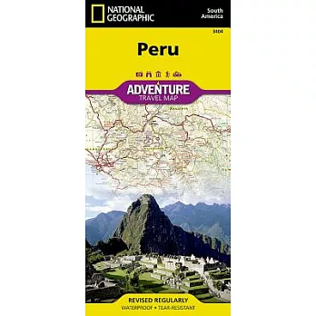
National Geographic’s Peru Adventure Map provides global travelers with the perfect combination of detail and perspective. Hundreds of points of interest and diverse and unique destinations are highlighted including World Heritage sites, archeological sites, churches, museums, and more. This map includes the locations of thousands of towns and villages, plus a clearly marked road network complete with distances and designations for highways and roadways. Rough tracks that require four-wheel drive vehicles and paths are included for adventurers seeking to explore more remote regions. National parks and reserves, wildlife centers, beaches, caves, waterfalls, and spas are clearly indicated so travelers can take advantage of Peru’s many natural attractions and activities.
The northern half of the Peru map includes the regions of Loreto, Tumbes, Piura, Amazonas, Lambayeque, Cajamarca, La Libertad, Ancash, Huánuco, and Ucayali. This section of the map spans from Peru’s borders with Ecuador and Colombia on the north and Brazil on the east, down to the coastal city of Chimbote. The regions of Tacna, Puno, Pasco, Moquegua, Madre de Dios, Lima, Junín, Ica, Huancavelica, Cusco, Ayacucho, Arequipa, and Apurímac are included on the southern half of the map.
In the language of the Quecha Indians, Peru means "land of abundance." Situated on the Pacific coast of South America just south of the equator, it was home to the great Inca empire which was destroyed in the early 16th century by Spaniards who pillaged the region of gold and silver to build their own empire. Today, Peru’s abundance is measured in natural resources. Its fisheries are some of the world’s richest. The country is also home to one of the world’s oldest petroleum industries and is one of the top producers of silver, lead, and zinc. Peru’s geography if varied, from arid coastal plains to the majestic peaks of the Andes mountains and the tropical forests of the Amazon basin.
Every Adventure Map is printed on durable synthetic paper, making them waterproof, tear-resistant and tough -- capable of withstanding the rigors of international travel.
- Map Scale = 1:1,650,000
- Sheet Size = 37.75" x 25.5"
- Folded Size = 4.25" x 9.25"


 博客來
博客來 博客來
博客來 博客來
博客來 博客來
博客來 博客來
博客來