HOT YLE英檢
Remote Sensing Handbook - Three Volume Set

Remote Sensing Handbook - Three Volume Set

  • 定價:45000

分期價:(除不盡餘數於第一期收取) 分期說明

3期0利率每期150006期0利率每期7500
  • 運送方式:
  • 臺灣與離島
  • 海外
  • 可配送點:台灣、蘭嶼、綠島、澎湖、金門、馬祖
  • 可取貨點:台灣、蘭嶼、綠島、澎湖、金門、馬祖
載入中...
  • 分享
 

內容簡介

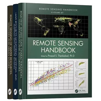
A volume in the three-volume Remote Sensing Handbook series, Remote Sensing of Water Resources, Disasters, and Urban Studies documents the scientific and methodological advances that have taken place during the last 50 years. The other two volumes in the series are Remotely Sensed Data Characterization, Classification, and Accuracies, and Land Resources Monitoring, Modeling, and Mapping with Remote Sensing.

In true handbook style, this volume demonstrates in-depth, extensive and comprehensive coverage of Remote Sensing of Water Resources, Disasters, and Urban Studies. The book provides fundamental as well as practical knowledge of remote sensing of myriad topics pertaining to water resources, disasters, and urban areas such as hydrology, water resources, water use, water productivity, floods, wetlands, snow and ice, nightlights, geomorphology, droughts and drylands, disasters, volcanoes, fire, and smart cities.

Highlights include:

  • Hydrological studies, groundwater studies, flood studies, and crop water use and water productivity studies
  • Wetland modeling, mapping, and characterization
  • Snow and ice studies
  • Drought and dryland monitoring and mapping methods
  • Volcanoes, coal fires, and greenhouse gas emissions
  • Urban remote sensing for disaster risk management
  • Remote sensing for the design of smart cities

Considered magnum opus on the subject the three-volume Remote Sensing Handbook is edited by Dr. Prasad S. Thenkabail, an internationally acclaimed scientist in remote sensing, GIScience, and spatial sciences. The volume has contributions from pioneering remote sensing global experts on specific topics. The volume gives you a knowledge base on each of the above mentioned topics, a deep understanding the evolution remote sensing science, and familiarity with state-of-the-art of technology as well as a future vision for the field.


作者簡介

Dr. Prasad S. Thenkabail is a well known global expert in remote sensing and spatial sciences. Currently, works as a Research Geographer-15 with the U.S. Geological Survey (USGS). Dr. Thenkabail has conducted pioneering scientific research work in two major areas: Hyperspectral remote sensing of vegetation; Global Irrigated and Rainfed Cropland Mapping. His research papers have won three American Society of Photogrammetric Engineering and Remote Sensing (ASPRS) awards: (a) 2015 ERDAS award for best scientific paper (second author), (a) 2008 ASPRS President’s award (first author), (b) 1994 Autometric Award (first author). He is the Editor-in- Chief of seminal books (Publisher: Taylor and Francis Inc.): (a) three volume (including this), 82 Chapter, Remote Sensing Handbook (November 2015), (b) Hyperspectral Remote Sensing of Vegetation (2012), and (c) Remote Sensing of Global Croplands for Food Security (2009). He is the Editor-in-Chief of Remote Sensing Open Access Journal and is on the editorial board of Remote Sensing of Environment, and ISPRS Journal of Photogrammetry and Remote Sensing. Prasad has work experience in 25+ Countries including working in key remote sensing research\leadership positions @ the International Water Management Institute (IWMI), International Institute of Tropical Agriculture (IITA), Yale Center for Earth Observation (YCEO), and the Indian National Remote Sensing Agency. He was selected by NASA and USGS as a member of Landsat Science Team Member (2007-20011), and was a scientific advisory board member of Rapideye (2001).

John G. Lyon has conducted scientific and engineering research and administrative functions throughout his career. He is formerly the senior physical scientist in the U.S. Environmental Protection Agency’s Office of Research and Development (ORD) and Office of the Science Advisor in Washington, DC, where he co-led work on the Group on Earth Observations and the USGEO subcommittee of the Committee on Environment and Natural Resources, and research on geospatial issues. Lyon was director of ORD’s Environmental Sciences Division for approximately eight years. He was educated at Reed College in Portland, Oregon, and the University of Michigan in Ann Arbor.


詳細資料

  • ISBN:9781482218015
  • 規格:電子書文件及線上資源 / 2200頁 / 35.1 x 25.4 x 20.8 cm / 普通級
  • 出版地:美國

最近瀏覽商品


相關活動

  • 【科普、飲食、電腦】高寶電子書暢銷書展:人生就是選擇的總和,全展75折起
 

購物說明

外文館商品版本:商品之書封,為出版社提供之樣本。實際出貨商品,以出版社所提供之現有版本為主。關於外文書裝訂、版本上的差異,請參考【外文書的小知識】。

調貨時間:無庫存之商品,在您完成訂單程序之後,將以空運的方式為您下單調貨。原則上約14~20個工作天可以取書(若有將延遲另行告知)。為了縮短等待的時間,建議您將外文書與其它商品分開下單,以獲得最快的取貨速度,但若是海外專案進口的外文商品,調貨時間約1~2個月。 

若您具有法人身份為常態性且大量購書者,或有特殊作業需求,建議您可洽詢「企業採購」。 

退換貨說明 

會員所購買的商品均享有到貨十天的猶豫期(含例假日)。退回之商品必須於猶豫期內寄回。 

辦理退換貨時,商品必須是全新狀態與完整包裝(請注意保持商品本體、配件、贈品、保證書、原廠包裝及所有附隨文件或資料的完整性,切勿缺漏任何配件或損毀原廠外盒)。退回商品無法回復原狀者,恐將影響退貨權益或需負擔部分費用。 

訂購本商品前請務必詳閱商品退換貨原則 

  • PRHUS
  • 小物